Bacalar, Quintana Roo - Mexico
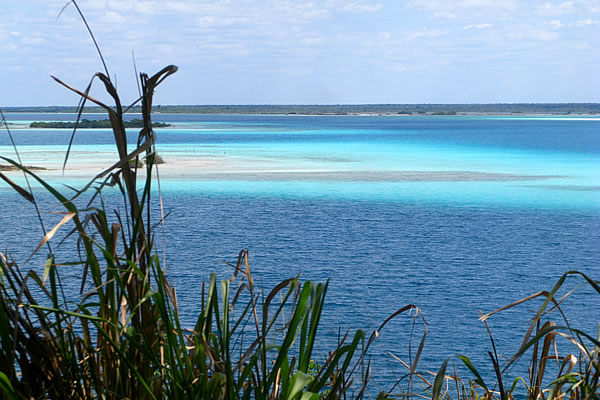
They call it the lake of seven colours. Looking a lot like its salty neighbour, the Caribbean Sea, Quintana Roo's Laguna Bacalar is a freshwater lake of clear blue water over a white sand bottom. The blueness isn't uniform, however: at times subtle, and at other times sharp changes in tone indicate a varied depth.
The Yucatan Peninsula is a dry place: neither rivers nor lakes lie on the surface, but instead travel underground. This is because the bedrock here is all limestone, the deposits of an ancient seabed. Limestone is easily dissolved by rain and eroded by flowing water and the seasonal rains have carved their way beneath the surface in a network of caves and submerged channels. All of this water eventually flows to the sea, and so as it passes through lower layers of bedrock, it re-emerges as a series of lakes, near sea level. The largest of these is Laguna Bacalar, just a few miles from Chetumal Bay.
The entire lake is about 50 km (30 miles) long, north to south. Never more than a km (about a half mile) in width, it runs parallel to the fault lines in the limestone bedrock. Standing on my balcony at the quirky and charming Hotel Laguna Bacalar in the early morning light, I can only see a short section of the water. The cool night air has shrouded the lake in mist. So unlike the sea, the lake in the early morning is mirror-flat. Small flocks of snowy egrets pass by on their way to rich feeding grounds. A glossy ibis cackles shrewdly in the dense foliage near the water's edge. A neotropical cormorant swims and dives around the dock, chasing the abundant small fish that make up its diet. It is morning, and the lake is just waking up.
A Day Trip
It is late morning, and the breeze has stirred up the lake to a light chop. We are heading south, towards the lake's source, escorted by a flock of violet-green swallows, their iridescent bodies shining in the morning light. To the west, the shore slopes upwards from the water. It is a mixture of dry forest and waterfront properties. Wealthy Mexicans and foreigners have built their humble palaces along this shore, though there is still plenty of wild forest between groomed gardens. The shoreline is irregular, often forming rounded bays of deep blue. These are cenotes, collapsed caverns, submerged beneath the surface of the lake. The eastern shore is low and swampy. Covered mostly in stunted mangroves, it is wild and undeveloped: part of a large protected area.
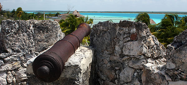
We are riding in a pontoon boat, a stable and comfortable platform for such a cruise. Some sit in the sun, others in the shade of a partial canopy. The lake is getting narrower and we pass the massive ruins of a resort that never quite got going before its owner, a former state governor, was jailed on drug trafficking charges. The ruins stand majestically and eerily through the trees, slowly being swallowed by the inevitability of the tropical forest.

The lake narrows to a river, and we see the beginnings of a current. The shore takes on a strange shape. It appears to be growing outwards at the surface, in billowing stone formations. These are extremely rare rock formations called microbialites. The oldest known fossils are a type of microbialite called stromatolites, dating back almost three and a half billion years. They are formed by cyanobacteria (blue-green algae), which consume carbon dioxide during photosynthesis, and cause dissolved calcium to precipitate around them as a thin layer of limestone. Thus the rock grows continuously outwards into the water, making this pillowy shoreline. There are only a handful of modern microbialites to be found anywhere in the world, and they are rarer still in fresh water, which makes this a special place indeed. The Laguna Bacalar Microbialite Formation is nearly ten kilometres (6 miles) long making it also the world's largest.
As we pass into the narrows, the current gets stronger. We see small fish darting among the reeds and jumping out of the water in front of the boat. The bottom is rocky and irregular with overhanging banks, and a straight channel, which splits near the downstream end. We motor through and Giovanni, our boat captain, turns the big rig around. The shoreline is fragile and so he holds a mangrove tree while we gear up and slip into the water.
Once we are all in, we drift downstream, masks in the water. The bottom and banks have a rough-looking texture. A closer look reveals that it is composed entirely of reefs of tiny freshwater mussels, imbedded in the limestone. Their shells are open as they filter the water streaming past them. And we stream past them, pulled along by the current, past deep hollows and beds of reeds, and propeller scars marking prior passages by less skilled boatmen.
In no time at all we are through the rapids and watch as Giovanni deftly manoeuvres the wide pontoon boat through the rapids and swings around to pick us up. Now we are heading back up the rapids to get to our picnic site, for lunch and a tour of the local flora, before we head back to our hotel (with one more swim through the rapids, of course). A great day on an unique and very interesting lake.